Deschutes County files mass appeal of hazard map
Published 12:59 pm Tuesday, February 25, 2025
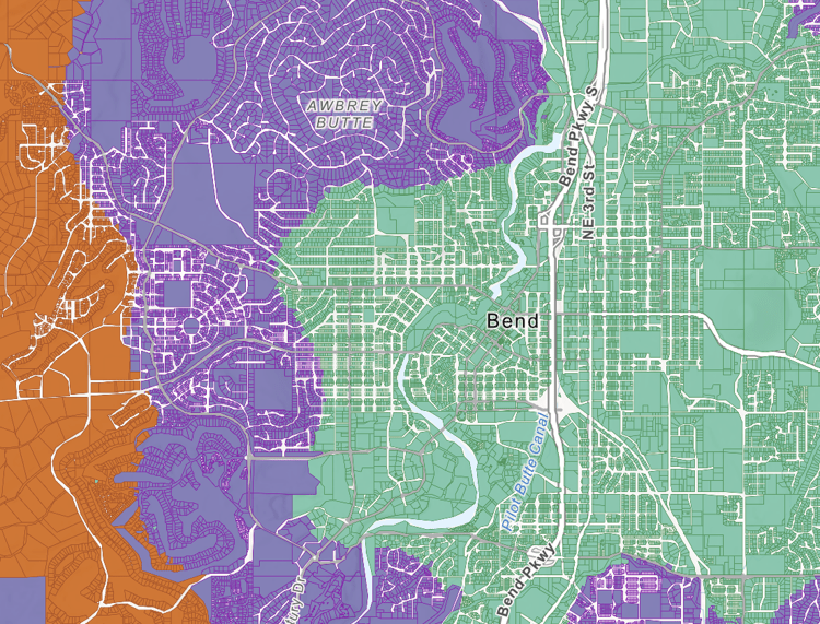
- Screenshot of Bend as depicted on the state's new wildfire hazard map. Green represents low hazard classification, purple is moderate and orange is high.
The Deschutes County Commission voted 2-1 Monday to file an appeal of the state’s wildfire hazard map on behalf of all 21,258 properties in the highest designation, a move intended to send a message to state lawmakers as calls to repeal the controversial map continue.
The mass appeal won’t change anything for private property owners who want to officially contest the state’s designation of their land, for which the deadline is March 10.
Because the county doesn’t know whether state rules allow governments to appeal on behalf of property owners, the commission is still encouraging private property owners to file individual appeals by the deadline, said Kim Katchur, a spokesperson for the county.
Trending
The gesture comes as county commissioners face pressure from property owners — mostly in rural areas — to advocate against the state’s map. Commissioners heard a succession of public testimony from upset landowners during a Feb. 12 meeting, but until Monday had not taken an official stance against the map.
Republican Commissioners Tony DeBone and Patti Adair were both in favor of filing the bulk appeal on Monday. DeBone, who earlier this month did not support a letter asking for a full repeal of the maps, said state lawmakers had suggested the county conduct a mass appeal to oppose the map.
Adair said she feels the mass appeal is the best way for Deschutes County to oppose the map.
“We need to do something,” she said.
Adair has been the most outspoken in opposition of the map, echoing landowners’ concerns that the map hurts property values, infringes on private property rights and places an undue burden on landowners to deal with wildfire risk.
In Deschutes County, 20% of properties are in both the high hazard and wildland-urban-interface designations.
Trending
The map ranks each property in Oregon as either low, medium or high hazard. Its purpose is to educate landowners about their wildfire hazard, assist with prioritizing firefighting resources and identify where new wildfire codes will apply.
Properties that are prescribed with the high hazard designation and within the wildland-urban interface will be subject to defensible space codes and home-hardening codes on new construction and significant renovations. The codes are still undergoing rulemaking at the state level.
Republican lawmakers have said the map, which is based on computer modeling from Oregon State University and the Oregon Department of Forestry, is “riddled with inaccuracies” and called for the Legislature to repeal the entirety of Senate Bill 762, the 2021 wildfire recovery bill that included creation of the map. Legislation has been introduced to repeal the map and other parts of the bill.
Some Democrats — including Sen. Anthony Broadman, D-Bend — have also said the state should repeal or at least retool the map.
“The rigidity of the wildfire maps is not working in communities like mine, and they are distracting from the work we are doing to get ready for the climate and wildfire catastrophe coming this summer and in the future,” Broadman said on the senate floor Feb. 20.
A previous version of the map was published in 2022 and repealed a few months later after public backlash.
“I think a lot of the smart money is these maps are probably going to get withdrawn anyway at the state level, and so a lot of this might just be posturing and not really have any practical impact,” David Doyle, the county’s lawyer said at the meeting.
Commissioner Phil Chang voted against the county’s appeal, and while not defending the maps themselves, he said he believes requirements to increase the number of wildfire-prepared homes in Oregon are necessary.
“My interest is actually doing something for the people of Deschutes County so that their house doesn’t burn to the ground,” he said. “This appeal and all this focus on the maps is not helping.”
Deschutes is not the only county seeking to appeal the hazard map at the county level, said Derek Gasperini, a spokesperson for the Oregon Department of Forestry, the agency in charge of the map. Similar discussions have taken place in Jackson, Josephine and Coos counties, he said.
Deschutes County is among the top five counties in the state for the number of properties that might be subject to new state codes, Gasperini said. Three-quarters of properties with the high hazard designation are located in Deschutes, Klamath, Josephine, Jackson and Wasco counties.
Local governments are allowed to appeal designations for land owned by the public agency, but not for private landowners, Gasperini said.
He said 846 property owners across the state have filed appeals. The data hasn’t yet been separated by county, he said.
The forestry department on Monday issued further guidance for the appeal process after Gov. Tina Kotek suspended agency action on all appeals Feb. 17. The department said property owners wishing to file appeals should do so by the deadline, but the state won’t send them to a hearings officer until after the legislative session concludes in June.
No research or preparation needs to happen prior to filing an appeal, according to the department.